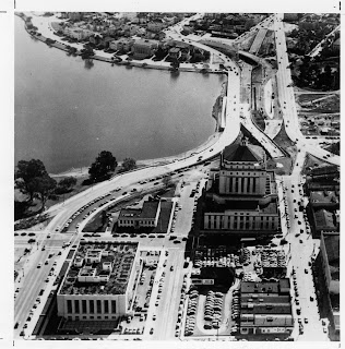
You may already know that Lake Merritt isn't a lake, but a tidal slough that various creeks and countless storm drains feed into. What you may not know is that it was originally freely connected with the estuary via a 600' wide opening, and early Oakland and nearby towns took advantage of the tidal action to use it as a sewer.
The lake covers about 140 acres, but is only 10 to 15 feet at the deepest during high tide. The areas closer to the shore are 4 to 8 feet deep, although in 1962 over 9 inches of rain fell in 24 hours, raising the water level by 7 feet and flooding surrounding streets and sidewalks.
In the 1860s, Dr. Samuel Merritt proposed financing a dam and cleaning up the new 'lake'. An early developer, he built a striking Italianate Victorian (Camron-Stanford House) along the shore and other wealthy landowners followed suit. In 1870 he moved to have the lake declared a wildlife sanctuary (the first in the U.S.), in part so residents wouldn't be bothered by the noise of hunters.
In the 1910s, the center of the boathouse (now the Lake Chalet) was built as a pumping station for the Oakland Fire Department. In 1913 the wings were added, and the same year the pergola at the north end of the lake was built.
The 1920s brought more changes. In 1920 the bandstand was constructed; in 1923, the Cleveland Cascade; and in 1925, the famous necklace of lights was completed. The necklace was dimmed during WWII for blackout conditions. The current necklace was relit in 1985 after a long campaign.
In 1950, building the Frickstad Viaduct turned a simple boulevard into "world's shortest freeway", destroying the gardens near the Kaiser Auditorium in the process. Originally they planned to build more of the civic center buildings there, but that never happened. Ironically, the useful life of the road widening was less than 10 years. At the time, it reduced a traffic bottleneck, but with the building of I-880 (then CA-17) and I-580, it was no longer as useful.
Now the 12th Street Project is working to restore some of the original water flow and natural beauty of the area. For the latest on the 12th Street Project, check out Erik Niemann's 12th Street Project blog. He contributed photos of the project for the new edition of Oakland: The Story of a A City and has a great time-lapse of the progress so far.
Update: If you thought the 12th Street freeway was bad, imagine if they'd built this monstrosity of a bridge, the "viaquadrome," that the Oakland Standard from the Oakland Museum recently posted.
Related links:
- old Oakland maps (compare 1877,1912,1936)
- Camron-Stanford House
- Once Upon A Time, Happily Ever After
- Cleveland Cascade
- Rotary Nature Center
- Gardens at Lake Merritt
- Lake Merritt Rowing Club
- Lake Merritt Institute
- Children's Fairyland
- 12th Street Project
- Cycling Through History
- OaklandMofo.com
- Jane's Walk
- Lake Merritt (Wikipedia)


2 comments:
Wow, that "viaquadrome" looks like it was designed for Lake Geneva, not Lake Merritt.
Or some body of water a lot larger than Lake Merritt. It's a cool design, but yowza...way out of scale for Lake Merritt.
Post a Comment